Blairgowrie: the walks

The Knockie and Cargill’s Leap
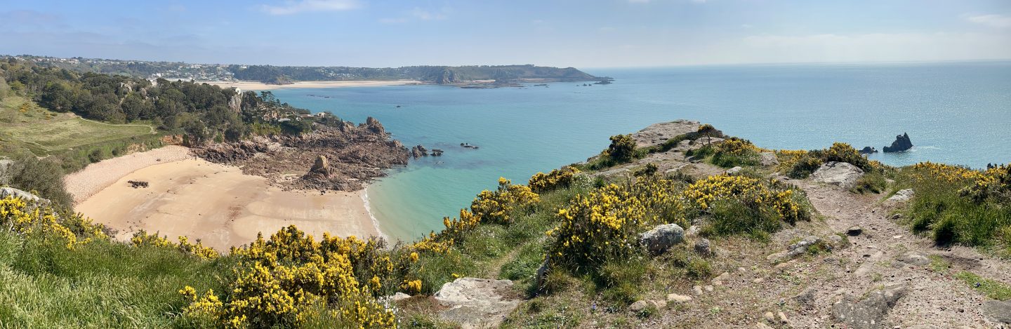
During our week in Blairgowrie in August, several of our walks began, or ended, by crossing the footbridge just behind The Old Furnace where we were staying. On Day 1, we followed a 3 mile / 5 km circular route, turning right at the end of the bridge to follow the River Ericht upstream and climbing Knockie Hill. At one time there were 11 mills along this river: Oakland, above, is now derelict, but we also passed Brooklinn Mill which has been converted to a private house. The area is very fertile, as some of the images show, and fruit farming is a speciality, hence the polytunnels.
Can you spot two cats in the second picture below? The real one looks a lot less alert than the fake one …


After descending the Knockie, we made our way through residential streets to the riverside. It was lunchtime, so we popped into Cargill’s Bistro, or at least onto its outdoor courtyard. How could we not, when it looked so welcoming? Lunch was delicious, as was the beer.


Our walk back took us along the riverside path, with its attractive sculptures, past Cargill’s Leap.


At Cargill’s Leap there is a viewing platform into the river below. This is where Donald Cargill, a local minster and covenanter, escaped pursuing troops by leaping the falls below. The covenanters were Presbyterians who signed a National Covenant in 1638 to retain their way of worship; this led to their persecution by Charles II. Cargill was eventually captured and executed.
I like the little figure on the information board!


From here, it wasn’t long until the chimney of our temporary home came into view and we re-crossed the bridge from which we had started.


Ardblair Trail and Bluebell Wood
On Day 2, we combined two short trails to make a 5 mile / 8 km figure-of-eight (plus about half an hour’s walk at each end to get to and from the Old Furnace). We made a lot of use of that riverside path! It was a good day for spotting quirky sculpture and painted stones, as well as more natural features such as assorted fungi and two pretty lochs.
As luck would have it, the figure-of-eight popped us out onto the road at lunchtime, right opposite the Dalmore Inn. Again, our powers of resistance were low. This time, we ate indoors, only the second time we have done so since the pandemic began. Their hygiene practices were excellent, and we felt as safe as its possible to be under the circumstances.


Drimmie Wood
Day 3 – another day, another wood! Drimmie is about two miles from Blairgowrie: we could have walked, but as you can see, the weather was not very pleasant so we chose to drive to the start of this 4 mile / 7 km trail. We were home by lunchtime, and went out again in the afternoon to explore Blairgowrie itself (pictures in last post).


River Ericht Path
On Day 4, the weather had improved somewhat. We chose to walk up one side of the River Ericht and back down the other, crossing at Kitty Swanson’s Bridge. (Kitty Swanson operated a ferry crossing here for many years in the late 1800s, and lived in a cottage nearby). The fertility of the area was again apparent, and we got a close up of those polytunnels (and a chance to sample some strawberries). This trail is about 8 miles / 13 km.


Loch of the Lowes
On Day 5, we drove a bit further, towards Dunkeld. In another circular walk (5 miles / 8 km), we left the car in the Cally carpark, and walked through woods, and a golf course, to the Scottish Wildlife Trust reserve at Loch of the Lowes. It was their first day open after months of closure and we’d had to book a time slot online beforehand. They were understandably nervous about their procedures but, again, we were happy with hygiene and distancing standards. The only problem was the main attraction, the ospreys, hadn’t got the memo. While smaller birds cooperated by putting on a show outside the visitor centre, the only thing we saw from the hide at the lochside (with lots of zooming) was a large, empty osprey nest. Not even any swans! Our local pond can do better than that …


We walked back to the car through Dunkeld, and at least we saw some handsome sheep to compensate. Some quirky signage too.


Stormont and Meikleour
Day 6, our last day, was wet most of the time, but we soldiered on. In the morning, we parked the car in the village of Carsie and made up a circular tour including Stormont Loch which just happened to take us past the Dalmore Inn again at lunchtime – what a coincidence! We only once got a glimpse of Stormont because it was surrounded by trees. Much prettier was the smaller Hare Myre, and an unexpected bonus was a honey farm.


After lunch, we drove on to the village of Meikleour where North Wood hides the Cleaven Dyke dating back to the Neolithic period. It just looks like a long mound!


The village itself is pretty and features the Meikleour Beech Hedge (snapped from the car) which is in the Guinness Book of Records as the tallest hedge in the world!


Conclusion
We had a lovely, relaxing week in Blairgowrie with comfortable, self-contained accommodation and gentle walks easing us into the idea of travelling again. All the trails we did, apart from Loch of the Lowes, are from the Perth and Kinross Countryside Trust Blairgowrie leaflet which you can download here. We found it really helpful.
On our way home to Glasgow we stopped in another pretty village with its own story to tell – but that can wait for next time.
Linked to Jo’s Monday Walk.


I like the image of Cargill leaping over the falls — and that was quite a leap! It would have been a happier story, though, if he hadn’t been executed.
Jude
LikeLike
Yes, that was rather rough on poor old Cargill!
LikeLike
Looks like you had a wonderful break Anabel! Some delightful walks, beautiful scenery and refreshments 🙂
LikeLike
We did! I hope we can do something else similar before the end of the year, assuming restrictions don’t spread to travel. Though can’t really assume anything at the moment!
LikeLiked by 1 person
No certainly can’t assume anything let alone plan at present!
LikeLiked by 1 person
You two always impress me going out for walks in almost all weathers! Looks like you had a marvellous break
LikeLike
On holiday we feel obliged to go out whatever the weather. At home, I can be more easily put off than John. I’m dreading the cold wet days of winter.
LikeLiked by 1 person
Getting MrB out even on holiday when the weather turns is not an easy task!
LikeLike
John has turned into a bit of an exercise fanatic!
LikeLiked by 1 person
well that’s good . . . although still not convinced about rainy walks!!!
LikeLike
He’s bought a bike which he prefers in wet weather, so I don’t have to be involved!
LikeLiked by 1 person
Phew for you!
LikeLike
Indeed!
LikeLiked by 1 person
Beautiful walks. I’m loving the sculptures and the wildlife photos 🙂
LikeLike
Thanks – they certainly were beautiful!
LikeLike
Anabel, I can’t imagine a more beautiful, relaxing holiday than to go walking in Blairgowrie. In addition to all the natural delights, the sculpture along the river is a joy. Here in the States we still haven’t braved the inside of a restaurant yet – fortunately it’s been so fun to sit outdoors. I’m sure that will change soon. Thanks for taking us with you on your lovely walks. ~Terri
LikeLike
It was such a lovely week, I’m glad you enjoyed reading about it.
LikeLiked by 1 person
What a wonderful week and a lovely change from living with restrictions. With all that walking, you could have stopped at a bistro or cafe every day and indulged as much as you wanted.
LikeLike
Well, we did eat out 4 times! 3 lunches and one dinner – thankfully, no discernible affect on the scales.
LikeLike
Hi Anabel – lovely walks around a very pretty area … definitely an area to visit. Love the sculptures, scenery and those pubs/inns … so good for us – just pity about life as its hit us … frustrating … still quiet in places. Such a pretty part of the world with some beautiful views. I enjoyed the ‘run arounds’ … take care – Hilary
LikeLike
Thanks Hilary, there was certainly plenty to do and see for a week. Just a change of scenery was a tonic.
LikeLike
This looks like a beautiful week that you both had, I love looking at all the pictures from the pretty towns to the hikes, funky art and funny signs. The last hike with the large trees and the circle of a hedge somehow made me feel uneasy. I know I sound like I should have flowers in my hair and looking at a crystal ball but I feel like I was there and it is unnerving. Weird yet it looks so beautiful.
LikeLike
It was a beautiful week, but sorry to make you uneasy! Perhaps you have been there in a past life…
LikeLike
Love the two cats, the bats stone, and the handsome sheep! I hope the strawberries you got to sample were better than the ones we’ve been growing in our garden – I think maybe they don’t get enough sun or something, because they look delicious, but when you taste them, blech! I’ve never had such bad strawberries!
LikeLike
These were perfect Perthshire strawberries! I always make a beeline for them in the shops.
LikeLiked by 1 person
What a busy week you had, so much walking and exploring but the weather looked perfect for it. Been to Blairgowrie briefly but just didn’t have time for a lot so keen to get back. Lovely photos.
LikeLike
We walked every day, but the trails were gentle and relaxing. It was so good to get some new scenery!
LikeLiked by 1 person
What excellent walks! And so varied, too. Looks like a great escape.
LikeLike
It was. I always love visiting Perthshire, it’s so green and pretty.
LikeLiked by 1 person
I love your walks Anabel! You have the prettiest scenery and all kinds of quirky creatures and sculptures. Thanks for the mini-field trip. In California we’re still stuck indoors–now due to the wildfire smoke. It’s refreshing to see your beautiful green countryside!
LikeLike
Thank you Joyce! I have been following the news from California and other places with wildfires. It must be even more awful on top of the pandemic problems.
LikeLiked by 1 person
What a lovely trip! And if you hadn’t said that was a hedge, I would have assumed it was a row of trees!
LikeLike
It’s beech, so I suppose it’s both – a row of trees trimmed into a hedge. Must be some job looking after it!
LikeLike
So much to see on your walks on this holiday. Red fungi ( what can it be) and so many tall trees. Lots of sculptures of course. And that fantastic hedge!
LikeLike
Yes, it was lovely to explore new things in a new area.
LikeLiked by 1 person
It seems so long since I could walk every day as you did that I am left slightly bemused at the energy you both display. Lovely walks and I enjoyed them with you. I was especially happy to see that the area is guarding their red squirrels. We have them here tool and try to keep the greys out. Lovely sheep yous saw!
LikeLike
If you saw me trudging along some days you might not be so impressed!
LikeLike
Didn’t realise so many walks existed around that area. Might actually stop for longer than ten minutes next time.
LikeLike
It’s pretty, if undemanding.
LikeLike
Anabel – It seems your neck of the woods has no end of picture-perfect towns and villages. Happy exploring! Cheers – Susan
LikeLiked by 1 person
Thanks Susan, it certainly does!
LikeLiked by 1 person
You certainly kept yourself busy with some wonderful and varied walks here. I must say reading this post made me realise I am getting things wrong. It is rare that there are pubs or cafes anywhere in the vicinity of the walks I am doing these days. I need to make amends!
LikeLike
Oh definitely! A walk with a good pub or cafe en route is the way to go.
LikeLiked by 1 person
I may have to consider a hip flask for some walks lol.
LikeLiked by 1 person
Looks like you kept the hospitality industry going single handed. Loved the carvings. Actually reminds me when dad was asked to give a talk to mum’s WI on walks of the New Forest. One senior member, in thanking mum said, ‘he does know a lot of pubs’, as they were always referenced on any of his walks.
LikeLike
Well, we had three lunches and one dinner which is exactly four times as many meals as we’d eaten out since March. It felt decadent! Since then – zilch. So it was a very temporary boost unfortunately.
LikeLike
Still its a start
LikeLiked by 1 person
Whew! I’m exhausted from following you two energizer bunnies around – and it was only my fingers doing the walking on my screen.😁 So many lovely spots and nice-sounding walks and dining experiences. Those are the most colorful bee boxes I’ve ever seen. Too bad about Cargill. Those Christians sure found lots of reasons to kill people. God’s will be done, right.
LikeLiked by 1 person
None of the walks were terribly long, so we had plenty of lazy mornings and evenings! It was just lovely to be somewhere different. There are many stories like Cargill’s up and down Scotland, unfortunately, and I know we are by no means unique.
LikeLiked by 1 person
I think an 8 mile walk on a nice river trail would seem a bit shorter that that distance on the rough trails here in the mountains.
I’ll never really understand why humans kill one another, but doing so over worshipping deities is the most mystifying.
LikeLike
Certainly is both mystifying and depressing.
LikeLiked by 1 person
Hi, Anabel – I had to look twice for the real cat. Yup, the fake one looks much more alert.
Thank you for another wonderful virtual tour. I’ll take all forms of travel that I can!
LikeLike
I loved the juxtaposition of the two black cats! With such contrasting demeanours …
LikeLike
That looks my idea of a perfect week! Thanks for the inspiration, Mel
LikeLike
Thank you! I’m glad you found the post enjoyable.
LikeLiked by 1 person
It all looks so wonderful and full of history. I am hoping we open up soon. I can’t wait to get out of here.
LikeLike
It gets really frustrating, doesn’t it? Someday your trip over here will happen.
LikeLiked by 1 person
Thumbs up… I hope.
LikeLiked by 1 person
What a lovely week of walks! In a very nice area. I wish we had explored more during our week up there, but there is so much to see.
LikeLike
That’s always our lament when we come home from anywhere! We wished we had longer.
LikeLiked by 1 person
Definitely a value for money post, Anabel 🙂 🙂 I love a riverside walk and you’ve given me several. Thanks a lot!
LikeLike
Thanks Jo! This is a very pretty river, and the fact that we could look out on it from our cottage, as well as walk along it, was an added bonus.
LikeLiked by 1 person
Such lovely walk. Thanks for the virtual tour. It is interesting to start venturing out a bit more now though we seem to still be very much restricted to surrounding areas but often there are great places to discover. (Suzanne)
LikeLike
This was lovely, because we were away from home and had access to different walks. Our local walks are becoming very over-familiar! Yet the algorithm that displays related posts reminded me that we did two of these walks on a day trip a few years ago – we were less than two hours from Glasgow, but it made all the difference.
LikeLike
We are doing the same thing around Montreal. We have been doing a few day trips to hike as well as explore new areas and we will do a 1-week trip to visit a few more parks with good hiking early October hoping to see good fall colours. It is always good to be able to have a change of routine. We are also a bit tired of the same old walks around the city…
LikeLike
I hope you take your camera on some of them! It’s always good to see other people’s walks too.
LikeLike
Yes we are though most of the walks aren’t as photogenic as the one you take. I might borrow your idea of the monthly gallivanting to present the few pictures we took. We don’t seem very inspired right now with the camera…
LikeLike
Yes, I find the idea handy for walks etc that don’t merit a whole post, though sometimes I get carried away and it gets too long!
LikeLike
Hi. Your husband looks delighted with the beer and with the locale. It’s good to be outdoors on a nice day, and even better when you add a beer to all of that!
LikeLike
The beer was certainly a delight! That’s the good thing about being able to walk straight from the front door without taking the car.
LikeLiked by 1 person
I’m so happy to see you out and about for so much walking. It certainly looked green there in August. I love that tall hedge and the sheep wearing the mask, and all the quirky signs. Also the little figure leaping over the stream and the stream itself. Doesn’t it feel good to be out and about? We loved our trip to Chicago at the end of August. It just felt so good to go somewhere different for a change. 🙂
LikeLike
It does feel good to be out and about! We had a lovely week. Of course, the countryside doesn’t get that green without a LOT of rain, but we only got wet on a couple of days. Mostly, it rained overnight – I approve of that.
LikeLike
I always approve of overnight rain when traveling. You were lucky to stay dry most of the time. 🙂
LikeLiked by 1 person
Oh, memories! You look like you had a great time. I knew I’d been to Cargill’s Leap, but as your week went on several names of forests I’ve orienteered in jumped out at me. Happy memories for us both!
LikeLike
We did have a good time, and I’m glad to have prompted happy memories of places you once knew.
LikeLike
Excellent. Blairgowrie looks very nice. I wonder if the name of Stormont Loch has anything to do with the Earl of Mansfield who owns Scone Palace. Viscount Stormont is one of his titles. I was at Scone on Saturday hence it came to mind!
LikeLike
That could be it! It’s not far away.
LikeLiked by 1 person